
Titan's North Pole Is Loaded With Lakes
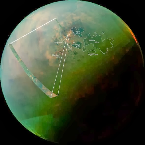
A combination of exceptionally clear weather, the steady approach of northern summer, and a poleward orbital path has given Cassini — and Cassini scientists — unprecedented views of countless lakes scattered across Titan’s north polar region. In the near-infrared mosaic above they can be seen as dark splotches and speckles scattered around the moon’s north pole. Previously observed mainly via radar, these are the best visual and infrared wavelength images ever obtained of Titan’s northern “land o’ lakes!”

Titan is currently the only other world besides Earth known to have stable bodies of liquid on its surface, but unlike Earth, Titan’s lakes aren’t filled with water — instead they’re full of liquid methane and ethane, organic compounds which are gases on Earth but liquids in Titan’s incredibly chilly -290º F (-180º C) environment. While one large lake and a few smaller ones have been previously identified at Titan’s south pole, curiously almost all of Titan’s lakes appear near the moon’s north pole. For an idea of scale, the large lake at the upper right above (and the largest lake on Titan) Kraken Mare is comparative in size to the Caspian Sea and Lake Superior combined. Kraken Mare is so large that sunlight was seen reflecting off its surface in 2009. Punga Mare, nearest Titan’s pole, is 240 miles (386 km) across.

Besides revealing the (uncannily) smooth surfaces of lakes — which appear dark in near-infrared wavelengths but would also be darker than the surrounding landscape in visible light — these Cassini images also show an unusually bright terrain surrounding them. Since the majority of Titan’s lakes are found within this bright region it’s thought that there could be a geologic correlation; is this Titan’s version of karst terrain, like what’s found in the southeastern U.S. and New Mexico? Could these lakes be merely the visible surfaces of a vast underground hydrocarbon aquifer? Or are they shallow pools filling depressions in an ancient lava flow?
Or, are they the remains of once-larger lakes and seas which have since evaporated? The orange-hued regions in the false-color mosaic may be evaporite — the Titan equivalent of salt flats on Earth. The evaporated material is thought to be organic chemicals originally from Titan’s haze particles that were once dissolved in liquid methane.
“Is this an indication that with increased warmth, the seas and lakes are starting to evaporate, leaving behind a deposit of organic material,” wrote Carolyn Porco, Cassini Imaging Team Leader, in an email earlier today. “…in other words, the Titan equivalent of a salt-flat?”
These observations are only possible because of the extended and long-term study of Saturn and its family of moons by the Cassini spacecraft, which began with its establishing orbit in 2004 and has since continued across multiple seasons over a third of the ringed planet’s year. The existence of methane lakes on Titan is undoubtedly fascinating, but how deep the lakes are, where they came from and how they behave in Titan’s environment have yet to be discovered. Luckily, the changing season is on our side.
“Titan’s northern lakes region is one of the most Earth-like and intriguing in the solar system,” said Linda Spilker, Cassini project scientist, based at NASA’s Jet Propulsion Laboratory, Pasadena, Calif. “We know lakes here change with the seasons, and Cassini’s long mission at Saturn gives us the opportunity to watch the seasons change at Titan, too. Now that the sun is shining in the north and we have these wonderful views, we can begin to compare the different data sets and tease out what Titan’s lakes are doing near the north pole.”
“But how thrilling it is to still be uncovering new territory on this fascinating moon… a place that, until Cassini’s arrival at Saturn nearly 10 years ago, was the largest single expanse of unseen terrain we had remaining in our solar system. Our adventures here have been the very essence of exploration. And it’s not over yet!”

Carolyn Porco on Facebook
Also, check out a corresponding article and intriguing illustration of robotic Titan exploration by space artist extraordinaire Ron Miller on io9.com.
Article by Jason Major originally posted on Universe Today
Source: My Science Academy
Titan is currently the only other world besides Earth known to have stable bodies of liquid on its surface, but unlike Earth, Titan’s lakes aren’t filled with water — instead they’re full of liquid methane and ethane, organic compounds which are gases on Earth but liquids in Titan’s incredibly chilly -290º F (-180º C) environment. While one large lake and a few smaller ones have been previously identified at Titan’s south pole, curiously almost all of Titan’s lakes appear near the moon’s north pole. For an idea of scale, the large lake at the upper right above (and the largest lake on Titan) Kraken Mare is comparative in size to the Caspian Sea and Lake Superior combined. Kraken Mare is so large that sunlight was seen reflecting off its surface in 2009. Punga Mare, nearest Titan’s pole, is 240 miles (386 km) across.
Besides revealing the (uncannily) smooth surfaces of lakes — which appear dark in near-infrared wavelengths but would also be darker than the surrounding landscape in visible light — these Cassini images also show an unusually bright terrain surrounding them. Since the majority of Titan’s lakes are found within this bright region it’s thought that there could be a geologic correlation; is this Titan’s version of karst terrain, like what’s found in the southeastern U.S. and New Mexico? Could these lakes be merely the visible surfaces of a vast underground hydrocarbon aquifer? Or are they shallow pools filling depressions in an ancient lava flow?
Or, are they the remains of once-larger lakes and seas which have since evaporated? The orange-hued regions in the false-color mosaic may be evaporite — the Titan equivalent of salt flats on Earth. The evaporated material is thought to be organic chemicals originally from Titan’s haze particles that were once dissolved in liquid methane.
“Is this an indication that with increased warmth, the seas and lakes are starting to evaporate, leaving behind a deposit of organic material,” wrote Carolyn Porco, Cassini Imaging Team Leader, in an email earlier today. “…in other words, the Titan equivalent of a salt-flat?”
These observations are only possible because of the extended and long-term study of Saturn and its family of moons by the Cassini spacecraft, which began with its establishing orbit in 2004 and has since continued across multiple seasons over a third of the ringed planet’s year. The existence of methane lakes on Titan is undoubtedly fascinating, but how deep the lakes are, where they came from and how they behave in Titan’s environment have yet to be discovered. Luckily, the changing season is on our side.
“Titan’s northern lakes region is one of the most Earth-like and intriguing in the solar system,” said Linda Spilker, Cassini project scientist, based at NASA’s Jet Propulsion Laboratory, Pasadena, Calif. “We know lakes here change with the seasons, and Cassini’s long mission at Saturn gives us the opportunity to watch the seasons change at Titan, too. Now that the sun is shining in the north and we have these wonderful views, we can begin to compare the different data sets and tease out what Titan’s lakes are doing near the north pole.”
“But how thrilling it is to still be uncovering new territory on this fascinating moon… a place that, until Cassini’s arrival at Saturn nearly 10 years ago, was the largest single expanse of unseen terrain we had remaining in our solar system. Our adventures here have been the very essence of exploration. And it’s not over yet!”
Carolyn Porco on Facebook
Also, check out a corresponding article and intriguing illustration of robotic Titan exploration by space artist extraordinaire Ron Miller on io9.com.
Article by Jason Major originally posted on Universe Today
Source: My Science Academy
Related Posts:
Titan's North Pole Is Loaded With Lakes
 Reviewed by Eli Snow
on
5:56 AM
Rating:
Reviewed by Eli Snow
on
5:56 AM
Rating:
Reviewed by Eli Snow
on
5:56 AM
Rating:


+-+This+is+Alaska's+Muir+Glacier+&+Inlet+in+1895.+Get+Ready+to+Be+Shocked+When+You+See+What+it+Looks+Like+Now..jpg)
حشرات المنزل يكثر في فصل الصيف انتشار الحشرات في أرجاء المنزل ومن أنواعها النمل والناموس والبق وغيرها من الأنواع الأخرى، الأمر الذي يبعث على الانزعاج والاستياء وقد تتسبب بإصابة الإنسان بالأمراض إذا لم يتم مكافحتها والقضاء عليها، ويجد العديد من الناس بأنّ طرق التخلص منها أمراً في غاية الصعوبة خاصةً أنهم لا يحبذون استخدام المبيدات الحشرية والمواد الكيميائية التي لا تحقق نتيجةً نهائية ناهيك عن الأضرار الصحية التي تُلحقها بالجسم، لذا يُفضل اللجوء إلى استخدام المواد الطبيعية التي تتميز بفاعليتها في القضاء على هذه الحشرات، وسنتعرف في هذا المقال على طرق مكافحة حشرات المنزل.
ReplyDeleteشركة مكافحة النمل الابيض بالقطيف
شركة مكافحة النمل الابيض بالخرج
شركة مكافحة النمل الابيض ببريدة
شركة مكافحة النمل الابيض بالدمام
Titan's landscape continues to astound. Imagine methane lakes instead of water bodies; what a different world! These images are simply stunning. slope unblocked and I remember once struggling to understand the differences between terrestrial and extraterrestrial geological processes in a planetary science class. It felt like grasping at thin air, much like understanding methane rain. The potential for further discoveries is immense, and Cassini's long-term mission is crucial to unlocking Titan's mysteries.
ReplyDeleteIt's fascinating to see how Cassini has given us such stunning views of Titan's lakes! The clarity and detail captured are truly remarkable. It’s like taking a cosmic journey through a landscape that feels entirely alien. Speaking of journeys, if you enjoy exploring unique terrains, you should definitely check out the game Run 3
ReplyDeleteReading about Titan and its methane lakes reminded me of my experience exploring the Arctic. The stark beauty of frozen landscapes and shimmering ice lakes brought a sense of awe, much like the images of Titan's lakes. Learning that these lakes hold liquid methane instead of water made me reflect on how diverse our universe is. The science behind these phenomena ignites a curiosity that feels boundless. For anyone looking for a light-hearted exploration of quirky concepts in a fun format, I recommend checking out Italian Brainrot Clicker. It's a unique pastime that will engage your imagination!
ReplyDeleteWow, Titan's looking awfully lakeworthy these days! So, Cassini's finally getting a good peek at all those northern lakes, eh? I wonder if alien fish are swimming around in those methane seas. Seriously, talk about a unique landscape! This reminds me of when I was trying to map out a network of hidden hiking trails in a heavily wooded area using only a really old GPS, it was a total shot in the dark, I felt like a lost drift hunters, constantly recalculating and reorienting based on very little information. What a headache!
ReplyDelete